
Discovery Map Available for Purchase
About the Frederick Law Olmsted on Staten Island
Discovery Map
The Friends of Olmsted-Beil House is happy to present the Frederick Law Olmsted on Staten Island Discovery Map.
This map illustrates some of the Staten Island locations associated with the life of pioneering landscape architect, author and social reformer Frederick Law Olmsted. All of the locations on the maps are numbered and accompanied by descriptions. The Discovery Map was created based on information from Olmsted’s letters, historical maps, and other sources, which are provided in the Source Guide.
The Discovery Map is composed of three separate illustrated maps plus the Source Guide:
- The first map is a watercolor illustration that shows Staten Island circa 1850. It includes where Olmsted lived, the places he landscaped, the ferries he took, and even where he shopped.
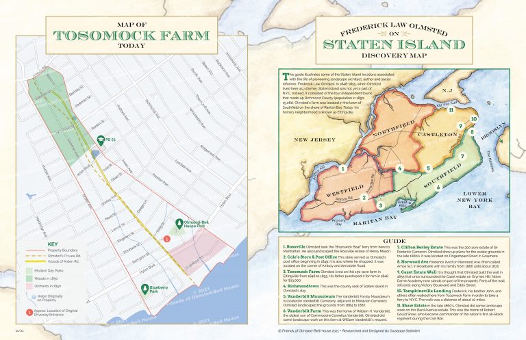
- The second map is a watercolor rendering of “Tosomock Farm,” the 130-acre farm where Frederick Law Olmsted’s talent for landscape design was discovered. It shows the location of some of the outbuildings, crops, orchards and more.
- The third map shows what is on Olmsted’s farmland today, including the current streets, public parks and buildings. Perhaps you or someone you know lives on Olmsted’s original farm property.
The Frederick Law Olmsted on Staten Island Discovery Map can be purchased at most of our events for $3. The map can also be purchased online with check or credit card payments accepted.
We hope this encourages you to visit the 1685 farmhouse and the Great Trees planted by Olmsted, in Olmsted-Beil House Park in Eltingville and to know that Olmsted still lives on Staten Island.